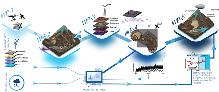
SHAKEN project aims at assessing not only spatial and size distributions of landslides triggered right after the February 6, Kahramanmaras earthquake sequence, but also its long-term effects on hillslope stability, which could lead to a chain of secondary hazards. Specifically, SHAKEN will create a comprehensive landslide event inventory and exploit Interferometric Synthetic Aperture Radar (InSAR) technology to monitor hillslope deformations over the earthquake-affected area. SHAKEN will identify actively deforming hillslopes based on past deformation trends and develop a novel method to predict hillslope deformations for short-term (i.e., 10-day ahead) forecasts derived from atmospheric models. This predictive tool will enable early warnings for potential high deformations that could result in catastrophic failures of critical sites and infrastructure.
SHAKEN project will have a strong impact on geohazard research and disaster perception and will train a new generation of Earth scientists to:
(i) better understand co- and post-seismic geohazard dynamics in the earthquake affected hillslopes, and
(ii) grow a new perspective in terms of the assessment of hazard chains and risks in understanding the long-term impacts of strong earthquakes on critical sites and infrastructure.
Monitoring and early detection of potential hazards after such devastating earthquakes threatens human life and are important for the sustainability and safety of critical military base structures, energy-critical structures in the region and for the lifelines like roads, energy transmission lines, dam reservoirs, etc. In this respect, the monitoring system and further integration of AI is aiming to reduce casualties and increase the safety of operating personnel and civilians. In addition, raising awareness of secondary hazards that can be experienced after similar strong earthquakes and a platform that can be developed with similar approaches can help to create a new tool to prevent and counteract and remediate in loco and rapidly the effects of the exposure to various critical situations, including hazard prediction capacity.
There are several scientific and technical deliverables envisaged by this project:
1- Co-seismic landslide inventory
2- Pre-and post-seismic hillslope deformation map of the study area
3- A predictive model targeting InSAR-derived surface deformation rates
4- A new module for the AFAD’s Disaster Risk Reduction System (ARAS) for the dissemination of the project’s outputs