The February 6, Mw 7.7 and 7.6 2023 Kahramanmaras Turkey earthquake sequence affected an area of ~100,000 km2 and significantly deformed hillslopes, which could lead to a chain of secondary hazards in the coming period. This project aims at assessing post-earthquake landslide hazard to inform Turkey's Disaster and Emergency Management Authority to take the required risk-mitigation actions to reduce the impact of secondary landslide hazards and to save people, critical infrastructure, lifelines and food supply chain. We propose to document co-seismic hillslope deformations and identify post-seismic landslide hot spots by developing a transferable artificial intelligence targeting hillslope surface deformations.
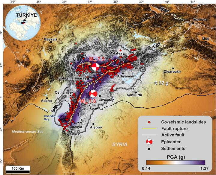 Figure: Spatial distribution of co-seismic landslides overlaid by the two main earthquake epicenters (USGS, 2023a,b), fault rupture (yellow, Reitman et al., 2023) and the USGS composite peak ground acceleration (PGA) map representing the maximum PGA recorded at each location for all quakes with a magnitude 5.5 and larger from the sequence (Goldberg et al., 2023). Major active faults (Emre et al., 2013) are indicated by white lines. EAF: Eastern Anatolian Fault, NAF: North Anatolian Fault.
NATO Science for Peace and Security (SPS) Programme
The NATO Science for Peace and Security (SPS) Programme is an integral part of the NATO Emerging Security Challenges (ESC) Division. The SPS Programme develops and implements practical cooperation and enhances dialogue between NATO nations and Partner countries through capacity-building and security-related civil science, technology and innovation. All SPS activities contribute towards the Alliance’s Strategic Objectives, have a clear link to security and respond to at least one of the SPS Key Priorities.

NATO HQ – Bd. Leopold III B-1110 Brussels – Belgium
You can find further information on our website:
www.nato.int/science
@NATO_SPS
E-mail: sps.info@hq.nato.int