Badland development and expansion is a major issue in geomorphological research field because it conduces to a variety of land degradation and sediment management problems such as loss of agricultural soil. Commonly observed geomorphic processes in badland areas are rilling, gullying, piping and various type of mass movements. Particularly gully development has the potential to destroy large areas of land surfaces in addition to the agricultural lands. This study aims (1) to analyze erosion processes in Nallıhan Badland area from multi-temporal UAV data and (2) to evaluate the spatial resolutions for the Digital Terrain Models (DTMs) derived from Unmanned Aerial Vehicle (UAV) in gully erosion mapping. A 5 km2 badland area in the Nallıhan Region (Ankara) was monitored with an unmanned aerial vehicle (UAV) and terrestrial laser scanning (TLS) over the period of one and two years, respectively.
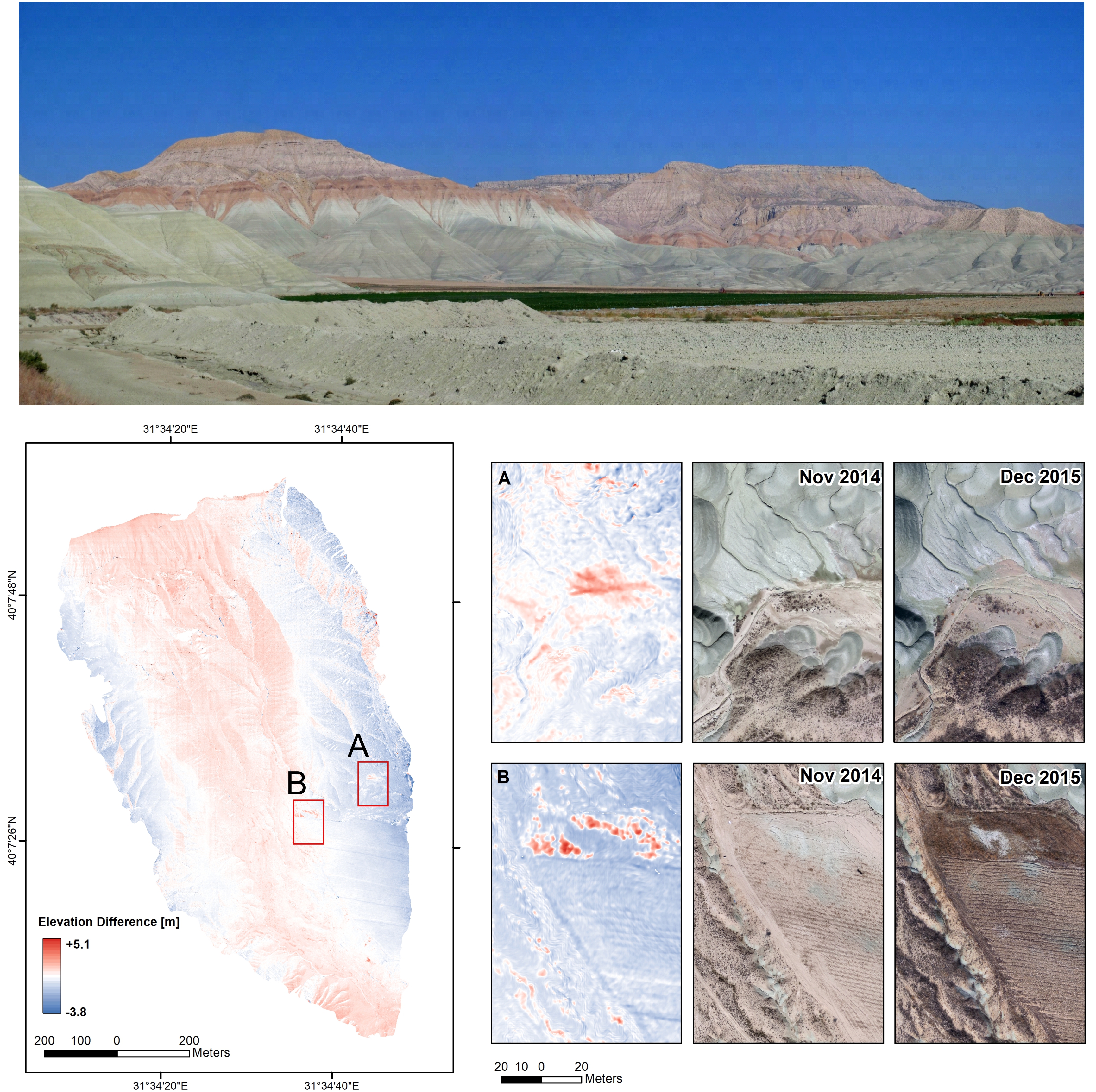 Figure. Nallıhan (Ankara) badland area. Differences of DEMs (DoDs) in the southeastern part of the catchment showing deposition and erosion areas for each monitoring period. The inset maps indicate depositional areas resulting from natural (A) and anthropogenic (B) activities.
Highlights
- The study revealed that depending on the decreasing of spatial resolution, the erosion rates calculated from the DTMs increase artificially.
- Several erosional processes, such as rill and gully erosion and shallow mass movements has been detected in the two-years monitoring period.
- DTMs comparison results showed that the differences in the calculated volumes of eroded material rate is more intense in the upper part of the catchment and mobilized sediments are damaging cultivated lands in the downstream section.
Publications related to this research:
Görüm, T., Avdan, U., Çömert, R. & Nefeslioglu, H., (2019). Sensitivity analyses for the DTMs derived from Unmanned Aerial Vehicle (UAV) in gully erosion mapping: Nallıhan badland area (Ankara, Turkey). Catena (In-progress).
Abstracts and presentations related to this research:
Görüm, T., Avdan, U., Çömert, R. & Nefeslioglu, H., (2017, October). Erosional Processes in the Nallıhan (Ankara) Badland Area based on Ultra-High Resolution Unmanned Aerial Vehicle (UAV) DTMs. In International Symposıum on GIS Applications in Geography & Geosciences Abstracts (Vol. 1, p. 250).
Avdan, U., Gorum, T., Comert, R., & Nefeslioglu, H. (2015, April). Sensitivity analyses for the DTMs derived from Unmanned Aerial Vehicle (UAV) in gully erosion mapping: Nallihan badland area (Ankara, Turkey). In EGU General Assembly Conference Abstracts (Vol. 17, p. 14058).