River dynamics studies, in particular, require high-resolution terrain models of both the riverbed and the floodplain. High discharges cause changes to the channel morphology, as well as the floodplain or the low flow channel. Spring flooding on a seasonal basis that can cause considerable geomorphic changes, while summer low flows also drive erosion and deposition in an ongoing process. Using accurate, high-resolution, seamless surface models of the river channel and floodplain allows detecting morphological changes of the whole river channel more accurately than using traditional methods. This offers a more comprehensive perspective of the evolution of the river channel possible. Therefore, high-quality topographical data at different scales are required to study fluvial processes and river dynamics. UAV systems offer several advantages in terms of cost and image resolution compared to terrestrial photogrammetry and satellite remote sensing system. Correspondingly, a combination of photogrammetry and UAV created a new term, which is UAV photogrammetry. In the study, a new methodology to create seamless high-resolution topographic models in river environments that bridge the gap between the satellite scale and field scale was developed. UAV-visualization was used to create very high-resolution surface models based on Structure from Motion (SfM) technique. Ultimately, multitemporal topographic data were produced, and morphodynamic processes in the lower course of the Büyük Menderes River in Turkey were modeled by digital shoreline analysis system and digital elevation model of difference methods. These methods were employed to examine the changes in the shoreline and to analyze the size of geomorphological changes and spatial patterns.
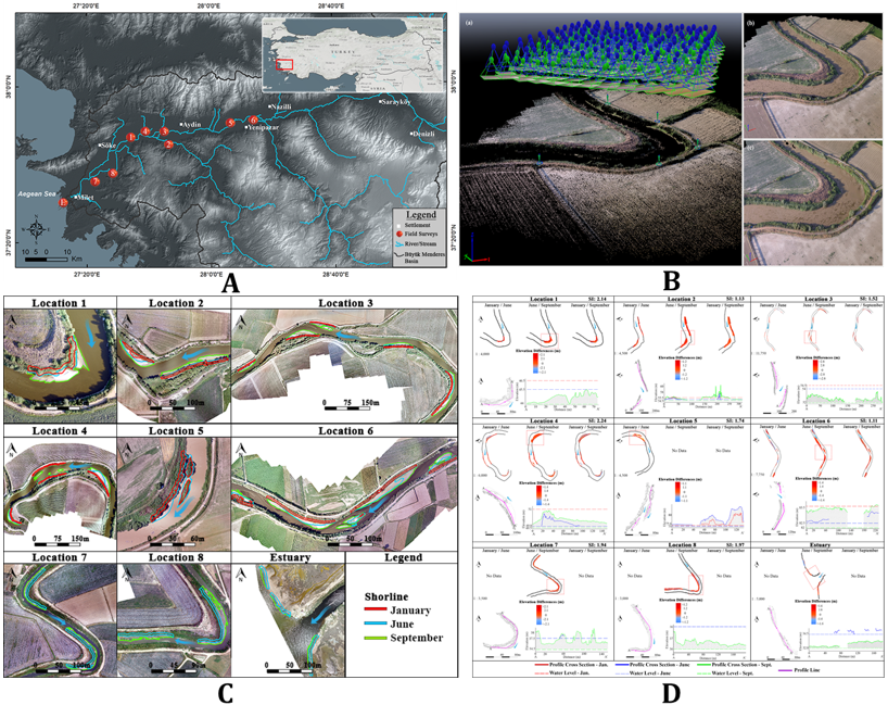 Figure. (A) Drainage network of the lower course of the BMR basin and field survey locations. (B) Demonstration of (a) the camera poses and sparse point cloud, (b) the dense point cloud, and (c) the 3-D mesh model (C) Shorelines extracted by DoDs. (D) Change detection along the shorelines extracted by DoDs. The red boxed area shows the profile drawn area. The left inset purple lines indicate the shoreline profile and profile direction. The right inset graphs produced with the profile show the water level and sediment quantities in January (red), June (blue), and September (green).
Highlights
- The change in the shoreline of the meanders varied from 3 to 27 m, and the water levels varied between ∼0.3 and 3 m.
- The predominant process was identified as deposition in the shoreline.
- A significant correlation was found between the deposited sediments and the sinuosity index values (r =0.88)
- Major changes on the deposition rate were found to occur mostly after the summer season.
Publications related to this research:
Akay, S. S., Özcan, O., Şen, Ö. L., (2019). Modeling morphodynamic processes in a meandering river with unmanned aerial vehicle-based measurements, Journal of Applied Remote Sensing, 13(4), 044523, doi: 10.1117/1.JRS.13.044523.
Abstracts and presentations related to this research:
Özcan, O., Akay, S., (2018). Modeling Morphodynamic Processes in Meandering Rivers with UAV-Based Measurements. IEEE International Geoscience and Remote Sensing Symposium - IGARSS, July 22 – 27, 2018, Valencia - SPAIN.
Özcan, O., Akay, S.S. (2018). Monitoring Hydromorphological Changes in Meandering Rivers via Multi-Temporal UAV-Based Measurements, AGU Fall Meeting, December 10 – 14, 2018, Washington DC., USA.